Maps and charts
Page 2 of 3 •  1, 2, 3

 Re: Maps and charts
![]() Guest Thu Oct 20, 2011 12:18 am
Guest Thu Oct 20, 2011 12:18 am
...lovely old maps Constance.
...I've always been keen on star maps.
This one's of Orion the hunter.
From the 3 stars that make up his belt you can locate many other constellations fairly easily.
Some people call this constellation the saucepan, or the pot.
Guest- Guest

Re: Maps and charts
![]() eddie Thu Nov 03, 2011 1:00 pm
eddie Thu Nov 03, 2011 1:00 pm
Take a wander round an addictive new website

Book Drum's new literary world map. Photograph: Book Drum
What a dangerous, dangerous website. I can tell I am going to have to limit my time on Book Drum's new literary map or I'm really not going to get anything done at all. Its creators say it's the first ever crowd-sourced literary world map, and it's already packed with information from contributors, from Wide Sargasso Sea, pinpointed in Granbois, Dominica ("based on Jean Rhys's father's estate of Bona Vista") and Thornfield, Yorkshire ("Antoinette is imprisoned in the attic at Thornfield Hall, where she is to be found, as Bertha, in Jane Eyre"), to Miss Smilla's Feeling for Snow in Greenland's Qaanaaq, the northernmost town in the world.
Text and pictures illustrate each location, giving a whole new insight, for generally-desk-bound-me at least, into the Gulf of Mexico (The Old Man and the Sea), The Chrysalids (set in a post-apocalyptic Labrador), the Chatham Islands of Cloud Atlas and the Congo of The Poisonwood Bible. Its creators hope users will enjoy working out puzzles such as how close Bridget Jones and Fanny Price lived, and how far the Snow Goose would have to fly to reach Brave New World's lighthouse: I've been having fun searching for the most remote tags – from Svalbard, Philip Pullman's armoured bear island from Northern Lights, to Lord of the Flies, which gets its little red pin on an "uninhabited tropical island" in the middle of the Pacific.
Just looking at the books scattered around me in my office, I'm desperate to start tagging latitudes and longitudes for Lauren Beukes's Zoo City, set in an alternate Johannesburg, for the Gravesend, New Hampshire of A Prayer for Owen Meany, for the zombie-ridden Manhattan of Colson Whitehead's Zone One. And continuing my interest in the remoter literary locations, where, I wonder, in the North Atlantic should Pincher Martin go?
My only worry is that if other people like the map as much as me, the planet will quickly become covered in pins and it'll become difficult to work out what's where. Australia, though, is currently something of a literary desert: let me go and find my copies of Walkabout, and The Thorn Birds, and A Town Like Alice, and start placing my little red pins.
eddie- The Gap Minder
- Posts : 7840
Join date : 2011-04-11
Age : 68
Location : Desert Island
Re: Maps and charts
![]() eddie Thu Nov 03, 2011 1:47 pm
eddie Thu Nov 03, 2011 1:47 pm
From Billericay to Westward Ho!, what's in a name?
Nicholas Lezard
guardian.co.uk, Tuesday 1 November 2011 09.00 GMT

'I come from Billericay' … Ian Dury.
What, the introduction prompts us to ask or discover, is the origin of the name "Billericay"? A good question, I thought, and looked it up. It turns out that when Ian Dury sang of coming from Billericay he was singing of coming from somewhere with a name taken "probably from a medieval Latin word belleri-ca meaning 'dyehouse or tanhouse'."

A Dictionary of British Place-Names
by AD Mills
I must admit that this information does not significantly add to our appreciation of the song; but it adds a tiny little bit to our knowledge of the past. Over 17,000 entries, this adds up. Sometimes our past can seep directly into our present. A friend of mine whose work takes her to Thurrock and who saw this book lying around asked me to look up the name, adding that she strongly suspected it meant "shithole". (Please do not blame me, brave and righteous sons and daughters of Thurrock. I only report what was said.) As it turns out, she wasn't too far out: it is from the Old English thurruc, meaning "a place where filthy water collects".
Then again, it's not all as good as this. Chichely in Milton Keynes is "the wood or clearing of a man called *Cicca". (The asterisk indicates that the name is "only evidenced in place- names and not otherwise recorded". So "Cicca" is a guess – but a very highly educated one.) Nawton in North Yorkshire means "farmstead of a man called Nagli". Dalston in Greater London means "hipster squat of a man called 'Dill'". Sorry: "Farmstead of a man called Deorlaf". Penistone ... not as exciting as you might think. Heanish: "Unidentified first element + OScand. nes 'headland'. Compare HYNISH." Hynish: "Unidentified first element + OScand. nes 'headland'. Compare HEANISH."
And so on: you could be forgiven for thinking that this is all mesmerically boring, rather in the way that a good long stint with the Domesday Book can be an excellent way of going to sleep. Which it is, if you're reading it in the wrong way. Looking for meanings that are interesting in and of themselves is not really the right way. But using them as a historical or socio-economic map of the British Isles is. For example, the persistence not only of Old English names, descriptive not just of the land in which the places are situated, but of the bigshot, local character, family or tribe who owned or occupied it in the first place, is testament to the resilience and influence of the pre-Norman population. In Scotland, you get quite a few Pictish names, predating the Scots; and a few names even more ancient than that. At the other end of the scale, you get Westward Ho!, not just the only place in the British Isles with an exclamation mark, but the only one named after a 19th-century novel, as opposed to the other way around. (Not that there's a real place called Middlemarch. Or not one in here at least.)
Names in Ireland are less centred on people, more on natural features; although one wonders what on earth happened for Killare in Westmeath to come by its name, which means "church of slaughter". (Note that this is a book which generously, and justly, covers the entire British Isles; and even some really tiny places manage to get a mention.) You notice, too, the varieties of natural description, the different ways land was cleared for use, descriptions of every different kind of undulation, different kinds of terrain. There are various trades: Meltham was so called because it was a place where smelting was done. If you wanted gravel then places beginning with "Gre-" were your best bet. You can see this happening now: near Cirencester there are signs directing you to "Honda" as if it were another town or village; but it's the Honda factory, as big and important as a small town. It's not in this book, but one day, in a future edition, it will be.
This is a book so meticulously and scrupulously compiled that it deserves not only salutation, then, but scrutiny. And everyone who lives in this country and is curious about it should have it on a shelf, ready to take with them before going for a long, curious walk.
eddie- The Gap Minder
- Posts : 7840
Join date : 2011-04-11
Age : 68
Location : Desert Island
Re: Maps and charts
![]() eddie Sat Feb 18, 2012 8:45 pm
eddie Sat Feb 18, 2012 8:45 pm
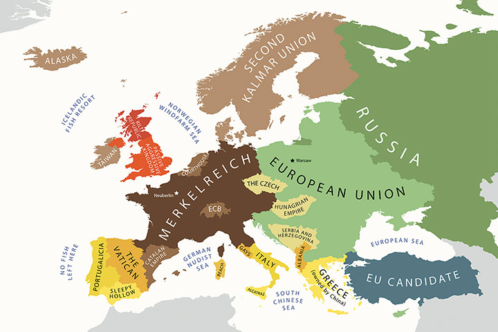
Tim Dowling is both intrigued and mildly entertained by graphic artist Yanko Tsvetkov's satirical maps of national stereotypes.
Tim Dowling
guardian.co.uk, Friday 17 February 2012 23.01 GMT

The World According to Americans, from Yanko Tsvetkov’s Mapping Stereotypes project. Click on the image to get a closer look.
There is nothing quite as obsolete as an out-of-date map: untrustworthy, suspect, politically incorrect. An atlas that still has Czechoslovakia on it may be historically interesting, but it illustrates a world that no longer exists. Change is constant: new countries spring into being, population centres shift, capitals are shunted from one place to another. With every adjustment, another map is rendered useless.
Why not map ignorance instead? In a fast-changing world, national stereotypes remain remarkably stable. View the globe from an American perspective and you can still get away with labelling the whole of Russia "Commies". If nothing else, it saves you having to spell Tajikistan.
The Mapping Stereotypes project is the work of Yanko Tsvetkov, a graphic artist who also goes by the name Alphadesigner. Tsvetkov has lived all over Europe, but back in 2009 when he got the idea to produce maps charting prevailing stereotypes, he was still in his native Bulgaria.
"There was a gas crisis, a pretty harsh winter, and we were a little bit cold," he says. His first map posited a Europe made up of competing interests and reductive presumptions. Russia is simply labelled "Paranoid Oil Empire". Most of the EU comes under the heading "Union Of Subsidised Farming". Turkey has been renamed "No YouTube Land" and where Georgia should be it says "Armed Winegrowers". He titled the map Where I Live and put it up on his website.
"People started leaving comments about it," Tsvetkov says. "People I didn't know. And then, by the unknown laws of the internet, it got quite popular." Tsvetkov realised this could be the beginning of a larger project. He made a map of "The World According To Americans", with Kazakhstan renamed "Borat", the Falklands marked "British Riviera" and all of North Africa summarised as "Fucking Desert, Dude". His map of Berlusconi's worldview is both hilariously vulgar and, one suspects, not far wide of the mark. No matter where you're from, you should be able to find something here to offend you.
To add to his growing collection, Tsvetkov has created two new maps for the Guardian, one titled The Arab Winter and the other Crystal Ball View Of Europe In 2022. In the former, Algeria has been renamed "Gaddafi's Sperm Bank" ("Because most of his family ran away to Algeria," Tsvetkov says, "so it's like a sperm bank for the preservation of his legacy"). In the latter a smaller territory in northern Italy has been coloured orange and labelled "Gays". "The region around Rome will be under gay occupation," he says, "because at some point all gay people will get tired of Pope Benedict's homophobic remarks and will invade the city to shut his mouth for ever." Most of the references are self-explanatory, although a working knowledge of geography (or, in my case, an old atlas with Czechoslovakia on it) comes in handy.
Tsvetkov himself is nowhere near as narrow-minded as his maps. He speaks several languages, currently lives in Spain and feels comfortable throughout Europe. "I have friends in most major European countries," he says. "I work as a designer, so we are a big community. We're like the European ideal." Has his cosmopolitanism also made him an expert on local prejudices and stereotypes? "Yes, there are things that you can only perceive when you are among the people, but the internet helps."
Tsvetkov has also lived in London, and in his Europe In 2022 map the UK (minus Scotland) is called Passive Aggressive Kingdom, a nickname that stems from David Cameron's recent refusal to sign an EU treaty. "It refers to the British way of thinking about Europe," Tsvetkov says. "It doesn't want to have much to do with the continent, but it wants to have a say. It's about wanting to achieve something by not doing anything."
Arguably these maps could do as much to reinforce stereotypes as ridicule them, but their primary purpose is to entertain. "If there is a serious problem, I prefer to present it in a funny say," Tsvetkov says. "I think there is enough serious coverage, and loads of people who can analyse it way better than I can."
eddie- The Gap Minder
- Posts : 7840
Join date : 2011-04-11
Age : 68
Location : Desert Island
Re: Maps and charts
![]() eddie Sat Feb 18, 2012 8:48 pm
eddie Sat Feb 18, 2012 8:48 pm

The World According to Americans. Yanko Tsvetkov/Alphadesigne
eddie- The Gap Minder
- Posts : 7840
Join date : 2011-04-11
Age : 68
Location : Desert Island
Re: Maps and charts
![]() eddie Sat Feb 18, 2012 8:51 pm
eddie Sat Feb 18, 2012 8:51 pm

L’Europa Berlusconiana. Yanko Tsvetkov/Alphadesigner
eddie- The Gap Minder
- Posts : 7840
Join date : 2011-04-11
Age : 68
Location : Desert Island
Re: Maps and charts
![]() eddie Sat Feb 18, 2012 8:54 pm
eddie Sat Feb 18, 2012 8:54 pm
Crystal Ball View of Europe in 2022. Yanko TsvetkovAlphadesigner
eddie- The Gap Minder
- Posts : 7840
Join date : 2011-04-11
Age : 68
Location : Desert Island
Re: Maps and charts
![]() eddie Sat Feb 18, 2012 8:56 pm
eddie Sat Feb 18, 2012 8:56 pm

Europe According to the Greeks. Yanko Tsvetkov/Alphadesigner
eddie- The Gap Minder
- Posts : 7840
Join date : 2011-04-11
Age : 68
Location : Desert Island
Re: Maps and charts
![]() eddie Sat Feb 18, 2012 8:59 pm
eddie Sat Feb 18, 2012 8:59 pm

Europe According to Gay men. Yanko Tsvetkov/Alphadesigner
eddie- The Gap Minder
- Posts : 7840
Join date : 2011-04-11
Age : 68
Location : Desert Island

eddie- The Gap Minder
- Posts : 7840
Join date : 2011-04-11
Age : 68
Location : Desert Island
Re: Maps and charts
![]() eddie Wed Apr 25, 2012 8:05 pm
eddie Wed Apr 25, 2012 8:05 pm
Week-long celebration begins with re-enactment of the 1932 Peak District protest that gave Britons the right to roam
Martin Wainwright
guardian.co.uk, Tuesday 24 April 2012 15.42 BST

Ramblers take to the tracks across Kinder Scout in the Peak District, Derbyshire. Photograph: Don Mcphee
It's an event best seen through the eyes of a 10-year-old child who looked round the vast bowl of hills around Kinder Scout on Tuesday and couldn't conceive of a time when it was forbidden ground.
"It's so green and so beautiful, we get up there whenever we can," she said, peeping out from behind one of the hand-coloured masks of grouse and curlews made by Edale primary school for this year's 80th anniversary of the Kinder Mass Trespass.
Her comment rolled back the years for Elsie Gaskell, who was 10 in April 1932, when word spread around Manchester, Sheffield and the smaller Pennine industrial towns that the landlords and gamekeepers on the high moors were to be defied in strength.
"A mass trespass! I'd never heard of one and I was so excited," Gaskell said. "And so disappointed when my dad, who was in the Manchester Federation of Ramblers, said, sorry Elsie, I'm not taking you because there may be trouble."
Trouble there was, though only a skirmish that left one keeper with a broken leg and a handful of the invading alliance of ramblers, Young Communists and local factory workers nursing bruises and cuts. It was a very small tussle to trigger a momentous campaign, which led to the UK's national parks, and eventually the right to roam.
On Wednesday, there will be a major re-enactment of the marchers' pincer movement from Hayfield and Edale, meeting up by the Kinder Downfall waterfall to roar out the Red Flag. The launch event, starting a week of talks, walks and a "trespass-themed ceilidh" was a quieter chance for veterans to reminisce.
"I used my first wage packet from the steelworks when I was 14 to buy a bike to get out here," said 94-year-old John Bunting from Sheffield. "The aristocracy wanted to keep us out, but they were only using the land for murdering animals."
Stuart Maconie, the writer and broadcaster, picked up the theme: "The country was run in those days by the rich landed gentry," he said. "So different from the way things are today," he added to applause.
Present day dangers were highlighted by Kate Ashbrook, general secretary of the Open Spaces Society, who told the launch: "We cannot be complacent and treat Kinder as mere history. The threats which the trespassers fought are still very much with us, but in a different guise.
"We do not know the future of the public forest estate, we have no indication from the government when the coastal-access law will be fully implemented, new planning laws threaten green spaces, and a law change could threaten our ability to register land as village greens.
"Our countryside and our urban spaces and paths are being privatised: landowners erect intimidating gates and CCTV cameras next to public paths, public land is being sold; local authorities make gating orders on urban paths."
Derbyshire police, whose mild handling of the original trespass was noted at the time by the Manchester Guardian's reporter, benignly supervised car parking to avoid the village of Edale getting swamped. In the local pub The Rambler, the quip was that Wednesday's re-enactment wouldn't be as "mass" as the original, because health and safety rules were much more intimidating than any 1930s gamekeeper.
That was only a rumour; but the National Trust raised eyebrows last year with plans to fence off part of Kinder to allow erosion caused by visitors to heal. And the launch attracted its own polite but determined protest, from members of the Peak District trail bikers' club whose noisy machines are banned from much of the park.
"Our share of access is going down from 5% to 3%, while these people have got 90% now," said Alan Gilmore, before heading home with the posse on his mud-spattered machine. "We don't want to break the law or spoil anyone else's enjoyment, but it's right that we should have a share of the countryside too."
Prof Harry Rothman, whose father Benny was the good-natured but determined communist organiser crucial to the trespass and its aftermath, took the point. He said: "I have mixed feelings. In an area as quiet and pristine as this, I don't think people would want to see motorbikes on the green ways. But there must be other places. Who are we to say that other users of the countryside can't follow their enthusiasms and be happy?"
eddie- The Gap Minder
- Posts : 7840
Join date : 2011-04-11
Age : 68
Location : Desert Island
Re: Maps and charts
![]() eddie Wed Apr 25, 2012 11:21 pm
eddie Wed Apr 25, 2012 11:21 pm

Section of the Ordnance Survey map of Great Britain showing the Gray's/Thurrock area.
I've recently splashed out on two Ordnance Survey maps of the Brecon Beacons (Powys, Mid-Wales) where I'm hoping to take a week's holiday.
eddie- The Gap Minder
- Posts : 7840
Join date : 2011-04-11
Age : 68
Location : Desert Island
Re: Maps and charts
![]() eddie Wed Apr 25, 2012 11:24 pm
eddie Wed Apr 25, 2012 11:24 pm

Book One of Wainwright's beautifully drawn Guides to the Lake District.
eddie- The Gap Minder
- Posts : 7840
Join date : 2011-04-11
Age : 68
Location : Desert Island
Re: Maps and charts
![]() eddie Sun Apr 29, 2012 5:46 pm
eddie Sun Apr 29, 2012 5:46 pm
*************************************************************************************************************
Map of a Nation by Rachel Hewitt – review
An absorbing history of the Ordnance Survey charts the many hurdles map-makers have had to overcome
Ian Thomson
The Observer, Sunday 17 October 2010

Ordnance Survey maps have been sold to the general public since 1801. Photograph: David Sillitoe for the Guardian
From the hieroglyphs of Aztec Mexico to the red stripe of London's Central line, all maps are idealised representations of the world. A relief map of moorland fells can mesmerise with its geometric language of lines and symbols. Yet even with the world now so thoroughly mapped out by Google, many of us remain carto-illiterate. In the mid-1990s, drivers in Britain were wasting an extraordinary 80m gallons of petrol each year getting lost, according to the AA (one would hope that figure is lower now, thanks to satnav). Those of us with poor visual-spatial skills often find it easier to read road atlases upside down.

Map of a Nation: A Biography of the Ordnance Survey
by Rachel Hewitt
Maps of all kinds permit a greater understanding of history and the politics of cartography. Nazi map-makers redrew Europe's frontiers in the shadow of the swastika, with an emphasis on "Jew-free" (Judenfrei) areas of conquest. The first surveys of the Scottish Highlands were done to facilitate the crushing of rebel clans in the wake of the Jacobite uprising of 1745. In spite of their political intent, the maps provided a magnificent bird's-eye view of mid-18th-century Scotland. The bunched contour lines and triangulation points marked on modern-day Ordnance Survey maps would not have been possible without the earlier charting of Scotland. In this endlessly absorbing history, Rachel Hewitt narrates the history of our printed maps from King George II's "Scotophobic" cartographies to the three-dimensional computerised elevations of today. A marvel of exactitude and the quantifying imagination, the Ordnance project conjures a "Betjemanesque image" of cycle-touring and jolly tramps through bog and heather. Founded in 1791 as the Trigonometrical Survey, it nevertheless began life as a military venture, merciless to subject peoples.
Herself a keen hiker, Hewitt portrays a heroic enterprise assailed on all sides by professional vanities, lack of funds and other difficulties. In post-Culloden Scotland the map-makers had used a small, tripod-mounted telescope or prototype theodolite to measure sight-lines from landmark to landmark. Inevitably, their arrival in a land pacified by a foreign power aroused fears of continued surveillance. Half a century later, when the first Ordnance Survey map was released to the general public in 1801, the project was still viewed with suspicion. In intricate black-and-white the map revealed Britain's south-easterly corner as a mesh of bridleways, brooks and field boundaries. Few could have guessed at the difficulties involved. As the surveyors scanned the Kent horizon with their telescopes, locals had mistaken them for French spies.
Notoriously, in 1824 government map-makers moved to Ireland. Their presence provoked such levels of suspicion that it seemed the entire British judiciary, church and crown were under threat. The Irish Ordnance Survey became the subject of Brian Friel's play Translations; it remains an incendiary moment in Irish history.
The Irish were not the only people to see maps as instruments of intimidation and control. Hewitt charts the hostility shown to "engineer agents" by Romantic poets and writers. William Wordsworth, for all his avowed interest in the Ordnance project, was critical of those seeking to tame the countryside by means of their boxed precision instruments. The Board of Ordnance may share the enlightened conviction that the pursuit of knowledge was a sovereign good, but they preached a godless, functional clarity. For William Blake, the "ésprit géométrique" that defined the national survey project was nothing short of satanic. Why enslave the human mind to universal laws and the cold hand of rationality?
Triumphantly, the Ordnance Survey has swelled over the years into a cartographical institution that comprises 403 maps in the Explorer series of the British Isles. Each region, no matter how inaccessible, possesses its own "biography" of streams, pre-Christian earth mounds, coach stations and lay-bys. In her lively and informative narrative, Hewitt highlights the Ordnance project's legion of draughtsmen, surveyors, dreamers and eccentrics, and the disagreements that flared among them. Prior to the 18th century, Britain of course had its national maps, but, emblazoned with royalist insignia or overtly patriotic, their function was primarily symbolic. The entire nation is now mapped out in exact and unbiased detail. Something may have been lost by charting every last footpath, boulder and scree slope, but we have become more "map-minded" as a result.
Ian Thomson's The Dead Yard: Tales of Modern Jamaica won the Royal Society of Literature Ondaatje prize 2010
eddie- The Gap Minder
- Posts : 7840
Join date : 2011-04-11
Age : 68
Location : Desert Island
Re: Maps and charts
![]() eddie Sun May 27, 2012 3:45 pm
eddie Sun May 27, 2012 3:45 pm
With his new book about Britain's ancient pathways, author Robert Macfarlane completes a trilogy of his acclaimed meditations on landscape. Rachel Cooke meets him for a walk…
Rachel Cooke
The Observer, Sunday 27 May 2012

Author Robert Macfarlane walking along an ancient path at Ivinghoe Beacon, in the Chilterns. Photograph: Andy Hall for the Observer
Examine a large-scale map of the Essex coastline between the river Crouch and the river Thames, and you'll see a footpath which departs the land at a place called Wakering Stairs and heads east, straight into – or so it appears – the North Sea. A few hundred yards on, it veers north, heading out across Maplin Sands until, three miles later, it turns back in the direction whence it came, finally making landfall at Fisherman's Head, on the edge of Foulness Island.

The Old Ways: A Journey on Foot
by Robert Macfarlane
Can this carefully traced line be for real? Certainly. You are not hallucinating. This is the Broomway, a path that is said to date from Roman times, and when Robert Macfarlane agrees to go walking with me, it's his first idea. Am I excited about this? Yes, and no. I'm thrilled at the idea of heading out with Macfarlane; I feel like a marathon runner who's been invited to train with Paula Radcliffe. But then I read his book, The Old Ways, and anxiety rolls in, like Essex mist. The Broomway, which can only be crossed when the tide is out, is the deadliest path in Britain; Edwardian newspapers, relishing its rapacious reputation – 66 of its dead lie in Foulness churchyard – rechristened it "the Doomway". As he notes, even the Ordnance Survey map registers the "gothic" atmosphere of the path: "WARNING," it reads. "Public rights of way across Maplin Sands can be dangerous. Seek local advice." I admire Macfarlane hugely; I would love to watch him "walking on silver water" in the "mirror-world" that is the Broomway. On the other hand, I would probably prefer not to drown in the service of trying to tell you what a good writer he is.
In the end, I'm saved by our diaries, which match neither the tide tables, nor the schedule of a nearby military firing range. Instead, we meet at Ivinghoe Beacon in the Chilterns – a much less intimidating point that conveniently connects two of the other "old ways" in his book: the Icknield Way, which rises somewhere in south Norfolk, and the Ridgeway, which continues on through Oxfordshire, Berkshire and Wiltshire. Both paths compete for the title of "oldest road in Britain", and both provide, for those who walk them, what Macfarlane calls "communion with the prehistoric". They are spectral places, ghostly with the leathery feet of the ancient past – though admittedly such eeriness may seem elusive when first you pull up at a crowded National Trust car park on a fine Sunday morning. If all is Gore-Tex, it's hard to get in touch with woad.
Macfarlane, I can't help but notice, is currently the male literary critic's favourite action man; they adore his sentences, but they also, one senses, live vicariously through him. By rights, then, he should live up to their fantasies by looking a little different from all of them. He should be gnarled. He should have huge hands, and shoulders like boulders. In fact, he is aspen-slight, with a grave, elfin face, and a warm, earnest manner. He greets me in the aforementioned car park with a wave, and a grin, and then we get going. The walk he has chosen – it takes us a sauntering three hours – is clever: a boutique yomp that provides a perfect microcosm of the southern British landscape. First there are fields, preternaturally green, and then a good Chiltern wood, with beech trees and yellow birdsnest, bluebells, celandines and a few plucky primroses. After this, there is a canal, where we see a heron take flight, and both of us say, at almost the same moment, how much it resembles a pterodactyl. A scramble up a railway embankment takes us to a road, and then into another wood, only now we are suddenly high up – or at least, high up for this part of the world – with a view into a valley, where we can see a reservoir, duck egg blue and perilously low. Finally, we walk along the line of a chalk hill, where a strange and lonely bonsai elder – "elders are bushes that long to be trees," says Macfarlane – cowers in the soft wind.
Along the way, we see a kite or two, and a skylark, hovering as if on the end of an invisible stick, but also a village dog-obedience class, and an archery competition. After weeks of rain, the sun shines all day long. It's so enchanting, and so very English, we might have stumbled into Rupert's Nutwood, or one of the William Brown stories. Is Macfarlane a good companion? Yes. It's not just that he talks so resonantly about music and books and Call of Duty (one of his students at Cambridge, where he is a don, recently presented a seminar on the computer game, which sounds like the end of days to me, though he insists not); it's the quality of his looking that I like. How is it that he knows the name of everything? His book is so full of unfamiliar words – gneiss, dolerite, transhumance, stupa, tain, chert – that it concludes with a lengthy glossary. He shakes his head. "I really am very poor with plants," he says. "I know my birds, though I'm not a birder. I know my trees ... reasonably. It's a vernacular acquaintance born of spending a long time outside."
The thought occurs that Macfarlane doesn't stumble on enchantment; he creates it. It is as though – batty as this sounds – it follows him about, the landscape and even the weather rising to meet the challenge of his prose. His books, he says, could not be written without leaving his desk; they must be walked into existence (his first, Mountains of the Mind, was a meditation on altitude, and won him the Guardian First Book award; his second, The Wild Places, took in all that is left untamed on our islands; The Old Ways, a book about the consensual, habitual manner in which paths are formed and maintained down the ages, now completes this loose trilogy on the various ways we're shaped by landscape).
But you do wonder: which comes first? Does the walk incite the book, or does the book incite the walk? It's the former, he says, particularly in the case of this third volume.
"I originally thought I would make a long walk from the Wash down to Dorset, but in the end, the image of a single path was replaced with the image of a network, and that was when the book became really exciting. Paths are human; they are the traces of our relationships, in some ways. The book inevitably began to be about chance meetings, and so things would just ... happen. Someone put me in touch with Raja Shehadeh [the Palestinian lawyer and walker, who lives in Ramallah], and I wanted to write about trespass, and so I went to walk with him. There are lots of people in this book. It's a book about how walking is alive in so many people's lives, and is vital to the provision of metaphor as well as a sense of openness and encounter."
My own view is that The Old Ways might have been better – more unified, more powerful – without any foreign escapades; his adventures on these islands are plenty dramatic enough. You would pick it up for his account of walking the Broomway alone, which he does in bare feet, the better to feel the "brain-like corrugations" of the hard sand: "I took my shoes off, and placed them on a stand of eelgrass. For some reason, I couldn't overcome my sense of tides as volatile rather than fixed, capricious rather than regulated. What if the tides disobeyed the moon, on this day of all days?" But the book also takes him out to the lonely stack, Sula Sgeir, where the men of Ness, on Lewis in the Outer Hebrides, each year harvest gannets, to be salted and preserved and eaten through the winter (paths, you see, may be watery as well as stony), and where Macfarlane experiences an extraordinary epiphany.
And later to the Chanctonbury Ring, on the South Downs, where something spooky happens in dead of night: human cries hovering above his little tent. "I still find that hard to explain, rationally," he says. "I'm not a mystic, and yet this idea of setting out on these paths which are so profoundly and durably associated with time folding back on itself ... what I think I heard was owls, possibly tawnys, but there was a weird geometry to the event, these two voices that moved, and then joined, and were so human. The only reason I didn't flee was that it was two o'clock in the morning."
He sleeps in secluded bothies, and beneath venerable hedgerows. He meets tramps, pilgrims and exiles. He traces the footsteps of the artist Eric Ravilious, the poet Edward Thomas, and Nan Shepherd, the Grampian novelist. It is, in many ways, an unwieldy rucksack of a book. But if you had to suggest what connects each place, each thought, to the other, you would say: joy. "Yes, I really wanted to write about joy," he says. It is, he thinks, frustrating that so many of the words one is compelled to use in connection with the countryside are religious: the blessing of sunshine falling through trees, the grace of cool water on blistered feet. "The term 'spiritual' is so culturally contraband. But I've searched and searched, and there are no better words. Religious language is all we've got." Walking, like faith, is a balm: Charles Darwin used to solve problems with a particular circuit (the trickier the problem, the more circuits required); Edward Thomas used it to ease his crushing depressions. "Though it has limits. It didn't always work for him [Thomas]. Walks can be frustrating and tiring, and there might be a point where thought is annihilated." But still, it's worth saying it: walk, and you will probably feel better.
Macfarlane grew up near Nottingham. His parents are doctors. They were a camping family, and he had grandparents who were still climbing on Ben Nevis – with ropes and helmets – well into their 70s; the outdoors is in his blood. "But when I was 16, I did this marathon walk – the Lakeland 3,000 – and I came down at the end of it absolutely broken. Mountains had become purgatory, so I left them alone for a while." He went back to them later, of course, but his three books inadvertently tell a private story: they move, he says, "from an upward urge to a peripatetic ground level".
He stopped climbing because he lost his nerve: "I experienced an uncontrollable proliferation of possible negative outcomes, which is to say… fear." Will he ever return to it? "I went back to the Alps last summer for the first time in 10 years, and managed to fall, unroped, into a crevasse, which was rather unsatisfactory. Stuck. My feet kicking in the space below me." He laughs. Does his wife – he is married to the sinologist Julia Lovell and they have two children – worry about him? "No. She just thinks all will be well, and probably it will be. My record of competence isn't great. As a student, I went climbing in Kyrgyzstan, and the Russian guides ran a book on whether we would leave without serious injury. But I don't do really dangerous things."
He read English at Cambridge, and looks back now with "astonishment" on the boy he was. "I had colour posters of Harrier jump jets on my walls. Basically, I was still 15." But he loved the work, and pretty soon he knew he wanted to be involved in books. He was made a fellow at Emmanuel College while he was still writing his PhD (it was about originality and plagiarism in Victorian literature). "I don't quite know how it happened, but I love teaching."
His writing life, which began early – the acclaimed Mountains of the Mind was published when he was still in his 20s – has, he says, been a huge surprise. "I wanted to be a poet, and I wrote shockingly bad poetry. I wanted to be a novelist, and I wrote shockingly bad short stories." Finding his subject was – cue a slow intake of breath – another blessing, though he writes exceptionally slowly. "Every sentence in my book will have had between 20 and 100 versions of itself."
We've been sitting on a bowered carpet of beech nuts all this while. But now it's time to make for the car. Macfarlane, having offered me a last square of Dairy Milk – hooray that it's not fair trade organic with 90% cocoa solids! – pulls on his sweater; the wind is up a little. Like one of the heroes of his book, Edward Thomas, he is, I've noticed, borderline obsessed with weather – as attentive to it as a lover. "Yes, but without being too pernickety about prepositions, I'm interested in thinking in the weather, not about it. Most of our prepositions suggest separateness from the weather world. But we are natural barometers. We are weathered."
In his book, he writes of a Gaelic expression that describes the fleeting shadows cast on moorland as clouds scud across the sky on a bright, windy day. What is it again? "I think it's rionnach maoim," he says, pleased that I've remembered it. "That precision. The beauty of exactitude. I'm working for that in my own writing."
And so we set off, reinvigorated by chocolate, and a language neither of us speaks.
eddie- The Gap Minder
- Posts : 7840
Join date : 2011-04-11
Age : 68
Location : Desert Island
Re: Maps and charts
![]() eddie Sun May 27, 2012 4:02 pm
eddie Sun May 27, 2012 4:02 pm

eddie- The Gap Minder
- Posts : 7840
Join date : 2011-04-11
Age : 68
Location : Desert Island
Re: Maps and charts
![]() eddie Sun May 27, 2012 4:05 pm
eddie Sun May 27, 2012 4:05 pm

eddie- The Gap Minder
- Posts : 7840
Join date : 2011-04-11
Age : 68
Location : Desert Island
Re: Maps and charts
![]() eddie Sun May 27, 2012 4:08 pm
eddie Sun May 27, 2012 4:08 pm

Original cover of Bruce Chatwin's Songlines.
eddie- The Gap Minder
- Posts : 7840
Join date : 2011-04-11
Age : 68
Location : Desert Island
Re: Maps and charts
![]() Guest Sun May 27, 2012 4:25 pm
Guest Sun May 27, 2012 4:25 pm

Guest- Guest
Re: Maps and charts
![]() Guest Sun May 27, 2012 4:29 pm
Guest Sun May 27, 2012 4:29 pm
eddie...I'm interested in but ignorant about ley lines. Do they need to intersect / connect? (I'd got the impression they were places of a sort of emanatory power.)eddie wrote:The problem with the ley line theory is that if you take enough randon points on a map, you're always going to find connections:
Last edited by blue moon on Sun May 27, 2012 4:31 pm; edited 1 time in total
Guest- Guest
Re: Maps and charts
![]() Guest Sun May 27, 2012 4:32 pm
Guest Sun May 27, 2012 4:32 pm
The page you are looking for might have been removed, had its name changed, or is temporarily unavailable.
Guest- Guest
Re: Maps and charts
![]() eddie Sun May 27, 2012 4:41 pm
eddie Sun May 27, 2012 4:41 pm
blue moon wrote:eddie...I'm interested in but ignorant about ley lines. Do they need to intersect / connect? (I'd got the impression they were places of a sort of emanatory power.)
I'll try to find some illustrations.
First up:

eddie- The Gap Minder
- Posts : 7840
Join date : 2011-04-11
Age : 68
Location : Desert Island
Re: Maps and charts
![]() eddie Sun May 27, 2012 4:46 pm
eddie Sun May 27, 2012 4:46 pm

Avebury circle.
Avebury Circle as Planetary Grid Umbilicus
(From: The Avebury Monuments,Faith de M. Vatcher, Lance Vatcher, Wiltshire Department of the Environment,
Her Majesty's Stationery Office, London, 1976)
eddie- The Gap Minder
- Posts : 7840
Join date : 2011-04-11
Age : 68
Location : Desert Island
Re: Maps and charts
![]() eddie Sun May 27, 2012 4:52 pm
eddie Sun May 27, 2012 4:52 pm

Geodesic grid formed over the map of England and Wales by a series of Alignments of High Peaks and Prehistoric Standing Stones
eddie- The Gap Minder
- Posts : 7840
Join date : 2011-04-11
Age : 68
Location : Desert Island
Page 2 of 3 • 1, 2, 3
|
|
|